Search
Handedness of rail traffic: left hand and right hand operation world wide.
Not visible in the map, but interesting to note, is that in France the trains normally drive on the left, except in Alsace where they drive on the right as a legacy of the time the province belonged to Germany.
Mapa of the train services of Catalunya (from [email protected])
You might not see it if you have specific languages selected and not catalan
cross-posted from: https://lemm.ee/post/44181347
> Source: https://old.reddit.com/r/catalunya/comments/1fwo5nn/he_fet_un_mapa_dels_serveis_ferroviaris_de/
Map of the Chagos Archipelago, constituting the British Indian Ocean Territory. UK has just announced that it will hand over sovereignty to the islands to Mauritius.
Source on UK ceding the islands to Mauritius
Wikipedia article on Chagos Archipelago
Another map displaying the main islands zoomed in.
Etihad Rail Network - Part of the Gulf Railway
Etihad Rail is one component of the Gulf Railway that will connect: Oman, UAE, Qatar, Bahrain, Kuwait and Saudi Arabia. So far it is the only part that is completed. Each country is responsible for its length of the railroad. The Arabian Gulf region is the least populated part of Saudi Arabia and therefore the Saudi length of the track is a low priority for the Saudi government and work is scheduled to start in 2026.
The evolution of Paris through historical maps (sources in comment)
A selective superposition of important evolutions of Paris' city limits. Based on this animation video on the evolution of the limits of Paris, from Roman antiquity to present days.
Sources :
- Nicolas Delamare, Traité de la police, Paris, chez J.Cot, 1705 : “Second plan de la ville de Paris” ; “Troisième plan de la ville de Paris”, par Antoine Coquart
- Plan de Truschet et Hoyau, 1553
- Plan de Jean Delagrive, 1728
- Plan d’Alexis Donnet, 1837
- Satellite picture of Paris by Sentinel-2B, ESA, 2018
Most of them are available in very high quality on the David Rumsey cartography center.
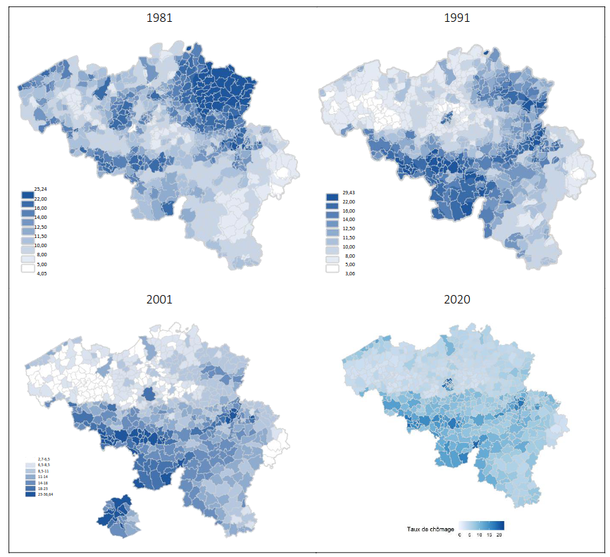
Unemployment rate in Belgium (2020)
In the map it can be clearly seen that the unemployment is higher in Wallonia than in Flanders. This is largely due to the fact that Wallonia has historically relied on its heavy industry, such as steel and coal, which has moved abroad the last decades. In fact, the Sambre and Meuse valley which was the industrial heartland in Belgium thanks to its coal resources, can be clearly seen on the map.
It is also interesting to see how the distribution of unemployment has changed throughout the years, as seen on these maps: !
2024 Indian Parliament election results - Maharashtra
Cyan - Congress (13 seats), Green - SSUBT (9), Orange - BJP (9), Pink - NCPSP (8), Yellow - SHS (7), Blue - NCP(AP) (1), Grey - Ind (1)
The shapefile is from the Election Commission of India website.
Habitat suitability of European forest categories
More info about the map and the forest types here. The forest types are described in chapter 6.
The map does not necessarily show what kind of forest actually grows in different places, if any, but rather which forest type you could expect to find there naturally, if it would be forest. But it probably matches reasonably well with what actual forests look like, although most of Europe is of course not covered by forests.
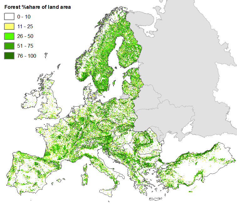
Here's a map over forest cover in Europe:
seriously you've gotta see this hat. you won't be able to tell it's a rhino when it's got it on


I know it's part of your transition period and are forced by law to continue the 100 year war on a culinary manner.
I'd say that the proper French culinary colonialist equivalent to the Tikka Massala is the Bahn Mi sandwhich and that feels like a proper match for it.
But now come up with a dish that doeesn't take any inspiration from former colonies and I think most of them can be beaten by a simple onion soup
I think this belongs more in [email protected]
But I chuckled so thanks for sharing
Zoomable version:
https://brilliantmaps.com/medieval-trade-routes/
A bit flowery on the language, but here's something for Deer Lodge
From this page
Through all the traditions of the Indians, the valley has been famous for the plenitude and fatness of the white-tailed deer that graze upon its ever-nutritious and almost ever-green grasses. And so the Indians, true to these facts, and weaving with them a happy fancy, named it after that which it most resembled; and we have it that the Snake hunting parties, approaching the crests of the surrounding mountains, before the pale-face came to the land, would try the fleetness of their steeds to see who would first catch sight of and hail the point of rendezvous "IT SOO-KE EN CAR-NE" "The lodge of the White-tailed deer". The early coming French, appreciating the poetry of the designation, adopted it literally, and among them it was known as La LOGE DU CHEV-REUIL. But the laconic, matter-of-fact Yankee pioneer came this way, and without remorse boiled down all its traditions and beauty and poesy into the practical appellation "DEER LODGE," by which name is now known the valley, the river, the county and town.
I like how "West" occurs in the East.
EDIT (2025-02-02T05:24Z): It just occurred to me that this might've been because the USA generally began on the east coast [2], so those states might've contained the western-most cities at the time — New Jersey, which is on the easternmost side [1], contains cities with "East" in their name.
References
- "Map of USA with state and territory names 2.png". Wikipedia. Published: 2019-09-09. Accessed: 2025-02-02T05:29Z. https://upload.wikimedia.org/wikipedia/commons/a/a4/Map_of_USA_with_state_and_territory_names_2.png.

- "Nouvelle-France map-en.svg". Wikipedia. Published: 2022-12-27. Accessed: 2025-02-02T05:31Z. https://en.wikipedia.org/wiki/United_States#/media/File:Nouvelle-France_map-en.svg.
 .
.
Indigenous names are heavily used. Half the states have Native American derived names, a much larger proportion than I thought. Pre-European population density was much lower, though so there were a lot fewer settlements to name.
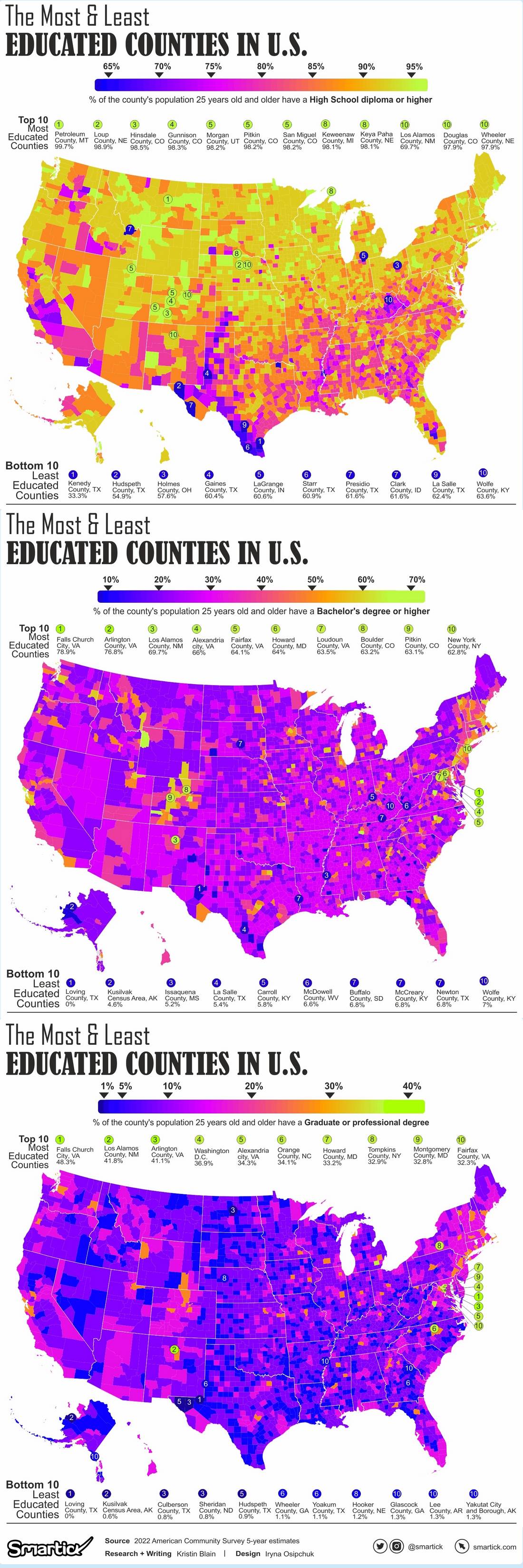
here's all the counties by education attainment. high school, 4-year college, graduate/professional degree.
source of the visuals:
www.smartick.com/data/visualizing-the-most-and-least-educated-counties-in-america/
using data from the census:
https://www.census.gov/data/developers/data-sets/acs-5year.html
The great salt lake doesn't connect to the ocean or any other shore and therefore is not a major shipping route. Also it may only be two more down than Ontario but it's an order of magnitude smaller.

I’ll never understand ’Muricans and their fetish for rulers.
[Edit: To clarify: I’m talking about the crazy straight borders.]
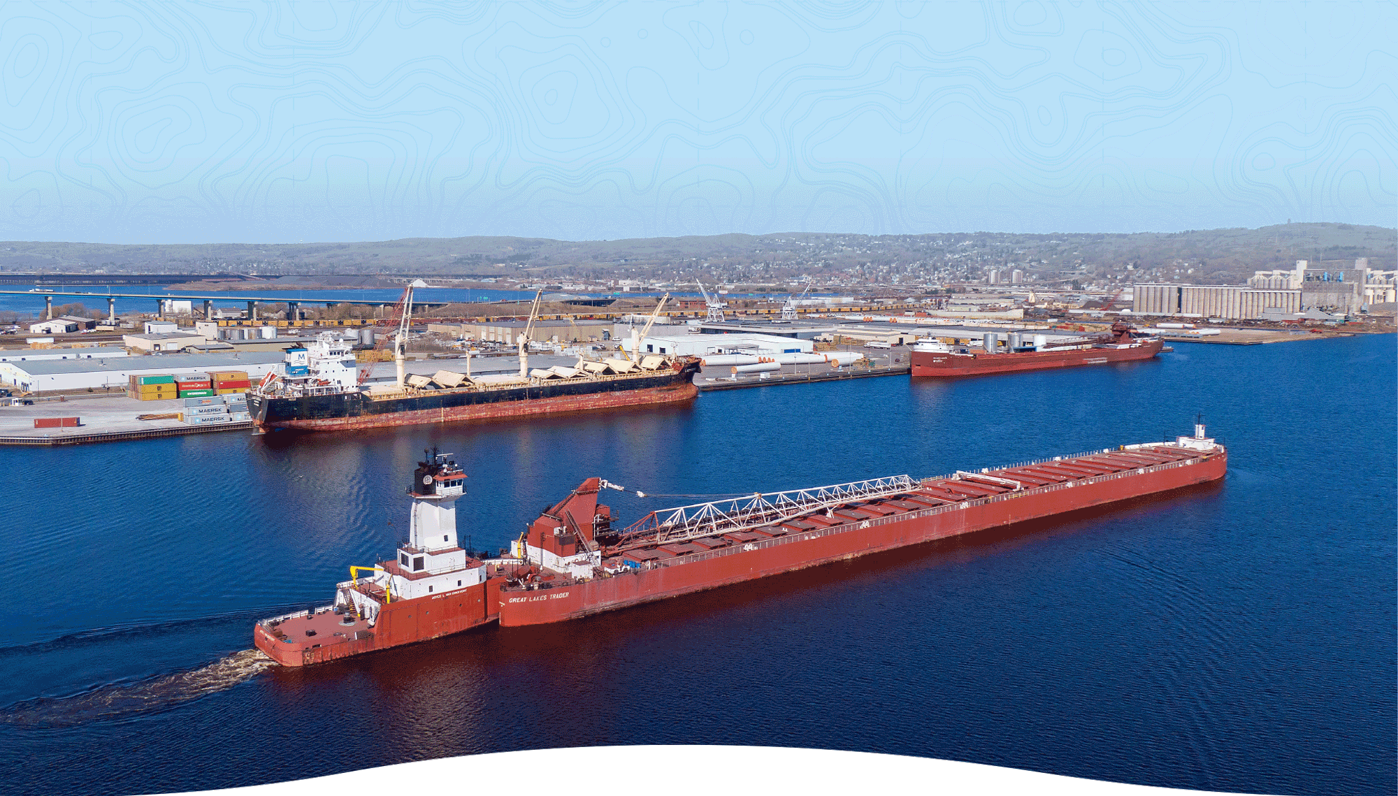
That's an image from Duluth, MN, the furthest port in the Great Lakes from the ocean. You think boats that big making it up some dinky river? Clearly a coast
Also, the coast guard operates in the Great lakes as well
Not a meteorologist but my understanding of the climate there, is that it is desert or close to it because of the topology. Very very windy where it isn't mountains.
And because I cannot try and know, this indicates it's going in the wrong direction.
In a global warming world it'll be prime real estate in a couple of generations though
[slaps car] "this thing will hold so many... climate refugees!"
That's why it's a miserable dump.
Enjoy the "Walk of Fame"

Which population numbers are you using for this graph? Census data for 2020 has LA county at 10.01 million and NC and Georgia at 10.45 and 10.73 million respectively. (for the second link, click on the Table 1 PDF. I didn't want to link to a PDF directly). 2023 numbers seem to have LA county trending down while those states are trending up.
It's still a staggering visual to compare population densities. I just thought the claim was a bit suspect regarding my state.
