Search
A while ago I've seen a before-after screenshot command line tool for osm mentioned somewhere but I cannot find it anymore.
@openstreetmap A while ago I've seen a before-after screenshot command line tool for osm mentioned somewhere but I cannot find it anymore. I believe it was written in python. Does anyone know the name of the tool in question?
Edit: Thanks to @richlv , this is it: https://github.com/amandasaurus/osm-mapping-party-before-after
Is there any documentation on mapping individual small plants like flowers or cacti?
@openstreetmap Is there any documentation on mapping individual small plants like flowers or cacti? I'd like to start mapping botanical gardens but cannot find any information on this.
Das Atomium in #Brüssel, gerendert in #cgeo auf der 3D #OpenStreetMap #Freizeitkarte sieht lustig aus.
Das Atomium in #Brüssel, gerendert in #cgeo auf der 3D #OpenStreetMap #Freizeitkarte sieht lustig aus.
OSM: Where zoos look like zoos
Attached: 2 images Glad to see the great job @[email protected] and @[email protected] are doing. For cycling to the zoo's main entrance, where I can buy entry, they suggest a sensible route. #Google maps seems to suggest I go through the zoo, possibly via the tiger cage. #OSM #Op...
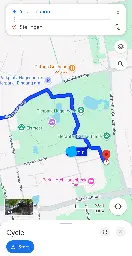
>Henry@[email protected] > > Glad to see the great job @openstreetmap and @organicmaps are doing. For cycling to the zoo's main entrance, where I can buy entry, they suggest a sensible route. #Google maps seems to suggest I go through the zoo, possibly via the tiger cage. > >https://social.lol/@hl/113047359789803891
>Dawid Rejowski@[email protected] > >@hl @openstreetmap @organicmaps > >Also somehow ZOO looks more like a ZOO. > >Here I needed a while to understand what is that place. Only after reading the labels I understood it is the center of Warsaw, a place that should be one of the most recognizable places in Poland.\ >Compared to OragnicMaps, with rich colors, colorful Metro icons, building shapes and rails, Google Maps looks very blended. > >https://101010.pl/@didek/113050389244877936
I need some help .
I need some help @openstreetmap.
UPDATE: Thanks for all the help!
What do I do, if a business has closed down, and then a new business has taken over the same place?
Do I mark the previous business as “does not exist” and add the new one, or do I edit the existing one?
Since my last anti-war post (in the broad, global, universal sense; and narrow sense of our project) had been included some comments about the dove, I've created an orthodox version a'la Pablo Picasso
Since my last anti-war post (in the broad, global, universal sense; and narrow sense of our project) had been included some comments about the dove, I've created an orthodox version a'la Pablo Picasso from 1949 😁 Whoever wants it, can use it! (I must say in general that the OSM logo is outstanding in its universality - and this magnifying glass as a symbol of search - sweetness 🍯💪 ). @[email protected] @openstreetmap
OpenStreetMap Community for Peace - logo for free use. @lemmy.ml
OpenStreetMap Community for Peace - logo for free use. @openstreetmap @[email protected]
We are bringing to #Wikimedia East, Southeast Asia & Pacific (ESEAP) 2024! 🗺️✈️🌏🇲🇾
We are bringing @openstreetmap to #Wikimedia East, Southeast Asia & Pacific (ESEAP) 2024! 🗺️✈️🌏🇲🇾
Join us on Sunday, 12 May, 11AM at Mahua 1 Room to learn how to map in #openstreetmap + link #wikidata!
Full program here: https://meta.wikimedia.org/wiki/ESEAP\_Conference\_2024/Programme
\#eseapconference2024 #ESEAP #ESEAP2024 #ESEAPKK24 #WikimediaESEAP #WikimediaESEAP2024 @seav @Supaplex
Crowdworked mapping: more fun in #OpenStreetMap! 🗺️ 🫶
Crowdworked mapping: more fun in #OpenStreetMap! 🗺️ 🫶
Traveled back to my home court #UPLB to bring the great news of #opendata #foss4g to young leaders! Grateful for the opportunity 🙏🏼🙏🏼
thank you besh @dfeyeandal for coming with! New #youthmappers chapter, yeah? 😉✊🏼❤️🔥
Join us this Saturday, 2 March for #OpenStreetMap Local Chapters and Communities Congress (LCCC) 2024!
Join us this Saturday, 2 March for #OpenStreetMap Local Chapters and Communities Congress (LCCC) 2024!
Let’s get together and discuss efforts to support &grow our mapping communities!
Register now & spread the word! 🗣️ https://tinyurl.com/osm-lccc24 #osmlccc24
See you! @[email protected] @openstreetmap
#shamelessplug 👀
my prolonged #OpenStreetMap diary about my experience as an OSMF board member. Apologies for the delay!
🪑🗺️community in the map and at the table: my first year and continuing plans as OSMF board member
2024: announcing the year of the #OpenStreetMap vector maps
2024: announcing the year of the #OpenStreetMap vector maps
https://blog.openstreetmap.org/2024/02/11/2024-announcing-the-year-of-the-openstreetmap-vector-maps/
OSM Teams is a tool for creating teams and roles in the #OpenStreetMap ecosystem for management of groups and communities to organize around existing tools like Tasking Manager, OSMCha, or iD, and
OSM Teams is a tool for creating teams and roles in the #OpenStreetMap ecosystem for management of groups and communities to organize around existing tools like Tasking Manager, OSMCha, or iD, and improves collaboration.
\- Found or find a team: https://mapping.team/teams
\- Video demo: https://www.youtube.com/watch?v=GSa4IWxZz4g
Not clear yet what the concrete benefits are, but it’s worth noting #OpenStreetMap has been registered as a “Digital Public Good” by the Digital Public Goods Alliance (#DPGA), which is a
Not clear yet what the concrete benefits are, but it’s worth noting #OpenStreetMap has been registered as a “Digital Public Good” by the Digital Public Goods Alliance (#DPGA), which is a multi-stakeholder United Nations-endorsed initiative. https://blog.openstreetmap.org/2024/02/05/osm-named-as-a-digital-public-good-by-un-affiliated-agency/
A nearby city call these crossings as "Gora¹ Lanes", an attempt to make walking fun, attractive, and accessible to more people.
A nearby city call these crossings as "Gora¹ Lanes", an attempt to make walking fun, attractive, and accessible to more people.
From the screenshot² below, it's something like an arty zebra (or "continental") crossing, and I saw minimal use of crossing:markings=artwork in #OpenStreetMap, and taggable with crossing:markings=yes.
I wonder how you folks might tag it.
¹ - Gora is an acronym from "Green Open Reclaimed Access" ² - Source: screenshot, https://yewtu.be/lKMFjLcTVkQ?t=59
When mapping street addresses in #OpenStreetMap, the minimum tag you probably need is addr:housenumber and addr:street, or maybe addr:place.
When mapping street addresses in #OpenStreetMap, the minimum tag you probably need is addr:housenumber and addr:street, or maybe addr:place.
In this example, house numbers 971 and 977 are the only two points actually mapped, and connected by a way tagged with addr:interpolation=odd.
The geocoder still returned the estimated position for the unmapped housenumber, 975.
Read about interpolation here: https://osm.org/wiki/Addresses#Interpolation
It's a quick method for adding street addresses in @openstreetmap
Have you been receiving unsolicited messages in your #OpenStreetMap inbox?
Have you been receiving unsolicited messages in your #OpenStreetMap inbox?
Well, it seems like this feature has been quietly introduced recently: "mute this user" link is now available for every @openstreetmap user page.
Apart from the @vespucci_editor and @osmandapp , do you know of any other mobile #OpenStreetMap editor that supports custom tile layers?
Apart from the @vespucci\_editor and @osmandapp , do you know of any other mobile #OpenStreetMap editor that supports custom tile layers?
When editing #OpenStreetMap on the go, @everydoor is my hands-down favorite, but I'd hesitate recommending it for more new mappers.
When editing #OpenStreetMap on the go, @everydoor is my hands-down favorite, but I'd hesitate recommending it for more new mappers.
I've been playing with #OsmGo just now, and really like how easy it is, maybe even for new contributors.
Plus, it's a progressive web app that runs in a browser, or installable in your device: https://osmgo.com , so this also seems to be a great candidate tool to introduce as a friendly editor for @openstreetmap mapping parties for new users.
If you're an #OpenStreetMap contributor, and active in the #Fediverse, where do you check for unexpected downtimes?
If you're an #OpenStreetMap contributor, and active in the #Fediverse, where do you check for unexpected downtimes?
You can follow the OSM Ops Team: @osm\_tech for technical updates.