
OpenStreetMap community
-
Panoramax on Android/iOS
Edit: Imagine Google streetview for OpenStreetMap, this is Panoramax. https://panoramax.fr/ https://wiki.openstreetmap.org/wiki/Panoramax
The free alternative to photo-mapping territories Panoramax is a digital resource for sharing and exploiting field photos. Anyone can take photographs of places visible from the public highway and contribute them to the Panoramax database. This data is then freely accessible and reusable by all.
During State of Panoramax panel at State of the Map France 2024, they announced a alpha/beta version for Android Panoramax application. Apk for android is available with the link and will be published on PlayStore and F-Droid. iOS users don't worry a version will be available too.
-
State of the Map 2024 in Łódź
stateofthemap.eu Łódź — SotM EU 2024State of the Map Europe 2024. International event of OpenStreetMap community that will take place in Łódź, Poland between 18th and 21st of July 2024.

18-21 July in Łódź, Poland
-
The major Organic Maps June update
organicmaps.app The major June update and a follow-up OSM data-only update (with a hotfix for the iOS app hanging) were successfully published and are available in all app stores and on our GitHub.The major June update and a follow-up OSM data-only update (with a hotfix for the iOS app hanging) were successfully published and are available in all app stor…
-
Changeset bounding box size limited for new users to combat recent vandalism waves
github.com Add the ability to limit changeset size by tomhughes · Pull Request #4908 · openstreetmap/openstreetmap-websiteThis aims to allow the bounding box of changesets to be limited. The basic technology is the same as #4319 with the maximum size ramping up over a period of time for new users. The defaults allow n...

-
Since my last anti-war post (in the broad, global, universal sense; and narrow sense of our project) had been included some comments about the dove, I've created an orthodox version a'la Pablo Picasso
Since my last anti-war post (in the broad, global, universal sense; and narrow sense of our project) had been included some comments about the dove, I've created an orthodox version a'la Pablo Picasso from 1949 😁 Whoever wants it, can use it! (I must say in general that the OSM logo is outstanding in its universality - and this magnifying glass as a symbol of search - sweetness 🍯💪 ). @[email protected] @openstreetmap
-
OpenStreetMap Community for Peace - logo for free use. @lemmy.ml
OpenStreetMap Community for Peace - logo for free use. @openstreetmap @[email protected]
-
Anyone know what's going on with the cycleOSM layer (June 2024)?
I'm seeing fake roads everywhere, and the map looks like a spider's web.
It's like this on every website that displays the cycleOSM layer: the official cycleOSM site, Openstreetmap, brouter, etc.
-
How can i convert a pbf file to pdf file
I downloaded a map from geofabrik.de and got it as a pbf can I somehow convert it to a PDF. Or is there a website where you can download OpenStreetMap as a PDF.
-
How to delete a Page on wiki.openstreetmap.org?
I stumpled upon an unmaintained list of used shop=* tags for Germany. Link: https://wiki.openstreetmap.org/wiki/Germany/Shops
Since there is https://taginfo.openstreetmap.org there is no need to have this page anymore, which is not updated since several years.
Anybody knows how to delete a page?
-
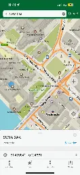
can you speed up osmand? it is incredibly slow on my pixel 6
It improved slightly with opengl but it's still very slow to render offline maps after years.
-
OpenGlobus: an Open-Source web map application library to display maps on a globe
github.com GitHub - openglobus/openglobus: TypeScript/JavaScript 3D maps and geospatial data visualization engine libraryTypeScript/JavaScript 3D maps and geospatial data visualization engine library - openglobus/openglobus

Just wanted to share this since I didn't find anything on lemmy about this. It's a pretty cool open-source project that I got introduced to while investigating a google maps / mapbox open-source alternatives for globe representation on the web.
Sorry if it doesn't fit into this community - didn't find a better community to post this and the sidebar says "OSM related software" posts are ok.
Here is a link to their website with examples: https://www.openglobus.org/
- media.ccc.de OpenRailwayMap – wie kommt das Signal auf die Karte?
Seit zehn Jahren stellt das Projekt OpenRailwayMap eine thematische Karte bereit, die Informationen über die Eisenbahninfrastruktur aus d...
Presentation (in German) about OpenRailwayMap at GPN (Gulaschprogrammiernacht).
-
The OsmAnd Birthday Quiz - including some funny answers ;)
forms.gle The OsmAnd Birthday QuizOsmAnd is celebrating its 14th anniversary! On this occasion, we would like to make a gift to our users who have been with us for a long time. Answer at least five questions of our QUIZ correctly, and you will get a gift! The questions vary in the number of points you can get for a correct answer. ...
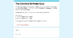
Answers accepted until June 6th. Gifts (a few months of osmand pro will be distributed by June 10th. Please, share among community!
-
[SOLVED] How would you tag this?
I’m referring to the advertising/digital display. I thought of using
man_made=advertising+advertising=*but not of the examples on the wiki seemed to match very well.EDIT:
I feel like an idiot for missing this but I found
advertising=screen(1) after posting thisEDIT 2: Fixed the examples link
-
[Osmand question] Graph widget elevation profile
Edit:
the problem is gone, i assume it was a buggy track.The problem exists with the versio 4.7.10, from 24.04.24, which is the version that is recommended by fdroid. It is gone in the latest one from 14.05.24I updated osmand to 4.7.10 yesterday and now it seems like the little info widget on the bottom screen shows elevation (i assume), relative to the whole track, not the 10km that are currently shown in the widget. Cannot find anything in the settings. In the what's new it said they did some changes to the graphs but i could not make sense of it.
Does anybody know how i can set it back to the way it used to be, as in relative to current section of the track?
- organicmaps.app The May 2024 Organic Maps update with bookmarks and tracks sorting by name, better paved/unpaved paths colors, GPX import fixes, drive-thorough, and many other changes
The May 2024 Organic Maps update (get it here) supports bookmarks and tracks sorting by name, paved paths are white, and unpaved ones are brown. And there are s…

-
Pokémon Go Players Altering OSM
arstechnica.com Pokémon Go players are altering public map data to catch rare PokémonOpenStreetMap contributors have been dealing with Pokémon Go players for years.

People are editing OSM to be able to get their Pokémon and others are changing OSM to mess with people so they can't get them
-
We are bringing to #Wikimedia East, Southeast Asia & Pacific (ESEAP) 2024! 🗺️✈️🌏🇲🇾
We are bringing @openstreetmap to #Wikimedia East, Southeast Asia & Pacific (ESEAP) 2024! 🗺️✈️🌏🇲🇾
Join us on Sunday, 12 May, 11AM at Mahua 1 Room to learn how to map in #openstreetmap + link #wikidata!
Full program here: https://meta.wikimedia.org/wiki/ESEAP\_Conference\_2024/Programme
\#eseapconference2024 #ESEAP #ESEAP2024 #ESEAPKK24 #WikimediaESEAP #WikimediaESEAP2024 @seav @Supaplex
-
How to map prepared and planned bus stops that are not in use yet?
Recently the city redesigned the street and prepared at least 4 bus stops. The stops all have the road markings and tactile paving, etc. but no bus stop signs yet and currently no line stops there. (There is an ongoing reorganization of bus lines in my area.)
The wiki page describes how to map a bus stop and I can follow along. Everything except the line(s) and the names is local knowledge.
How should those be mapped (if at all)? Map what’s known already and add
construction:bus_stop? -
Maurizio Napolitano on the importance of OSM in the world of digital commons
tube.network.europa.eu NGI Talk - Maurizio Napolitano - OpenStreetMap: A collaborative Ecosystem Serving Society & BusinessIn today's interconnected world, accurate geographic information is crucial for various applications, from urban planning to logistics. OpenStreetMap (OSM) stands out as a solution, offering a collaborative mapping platform that democratises access to geospatial information. Led by Maurizio Napolita...

-
Beware of Fake Beaches
community.openstreetmap.org Beware of fake beaches (Pokémon Go)Five days ago Niantic announced a new Pokémon in Pokémon Go, which spawns only in beaches. So it could happen that someone could add fake beaches in these days (I found two users already in Italy with a quick check), this is just a reminder to take a look in you local area. One method could be to fi...
Overpass Query:
//courtesy of WoodWoseWulf on Discord [timeout:240] [bbox:{{bbox}}]; ( way[natural=beach](newer:"2024-04-23T00:00:00Z"); ); out body; >; out skel qt;post has been crossposted since the original did not federate correctly with lemmy.ml
- github.com Release v57.3 · streetcomplete/StreetComplete
Fix UNDO: It didn't actually do anything for edits that were already synced! This critical issue existed since v57.2 (#5600, #5602) Traffic signals: Improve wording (#5591) Max speed: Show warning ...

StreetComplete is an easy to use editor of OpenStreetMap data available for Android. It can be used without any OpenStreetMap-specific knowledge. It asks simple questions, with answers directly used to edit and improve OpenStreetMap data. The app is aimed at users who do not know anything about OSM tagging schemes but still want to contribute to OpenStreetMap.
- www.graphhopper.com GraphHopper Routing Engine 9.0 Released - GraphHopper Directions API
We have released version 9.0 of GraphHopper, the flexible and fast open source routing engine for OpenStreetMap. Read more about it on GitHub, try GraphHopper Maps and read on to find out what’s new. The following contributors worked on over 40 pull requests and many more smaller changes: easbar, ka...
- www.openstreetmap.org GOwin's Diary | A more inclusive mapping party setup, for same-day imagery collection and mapathons. | OpenStreetMap
OpenStreetMap is a map of the world, created by people like you and free to use under an open license.
-
MapSCII - OSM console renderer
github.com GitHub - rastapasta/mapscii: 🗺 MapSCII is a Braille & ASCII world map renderer for your console - enter => telnet mapscii.me <= on Mac (brew install telnet) and Linux, connect with PuTTY on Windows🗺 MapSCII is a Braille & ASCII world map renderer for your console - enter => telnet mapscii.me <= on Mac (brew install telnet) and Linux, connect with PuTTY on Windows - rastapasta/mapscii

To connect simply run:
shell telnet mapscii.me -
Is there a way to see how many amenity=bench I have created?
I wonder how many I have already mapped.
-
Using OpenStreetMap to play the game in any location
store.steampowered.com Save 10% on Infection Free Zone on SteamChoose any real region from the world. Choose your base of operations, then rebuild and readapt the buildings around you to create a self-sustaining settlement. Take charge of a group of survivors from your city. And when the night falls - Defend the zone from the infected!
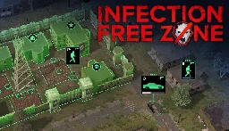
Pretty cool idea by using open street maps you can download the location you want and play the game there, defend your neighborhood or loot your house.
The reviews seem decent but mention it needs a lot of tweaking as it just released on early access, like water not affecting where zombies can walk or elevation not being a thing.
Maybe this can get some more people interested in mapping
-
Ordnance Survey now publishes its data in OpenStreetMap format
> 2004: OpenStreetMap is founded because Ordnance Survey won’t make their data open > > 2024: Ordnance Survey now publishes its data in OpenStreetMap format because that’s what people expect
-- Richard Fairhurst @richardf
-
Convert your OpenStreetMap-based application links into Google Maps, Apple Maps or other links (and vice versa) without having to use proprietary software!
osm2gmaps converts links from applications like Organic Maps or OSMand to proprietary maps links, like Google Maps or Apple Maps. Just copy the link and share it to osm2gmaps or copy and paste it inside the app, it will automatically convert the link to your chosen type and copy it to the clipboard.
-
Unmapped USA - Mastodon Bot
I thought I’d share this Mastodon bot - @SmallTownUSA - here as I’ve found it great fun.
> Posting towns in the USA with a population less than 1000 that are undermapped on OpenStreetMap.org
I quite enjoy mapping areas that have nothing or very little mapped. This bot kind of helps with that. Although, I’d love another one for my home country and current country of residence.
-
How to use different Nominatim on web openstreetmap
I would like to use openstreetmap as replacement for google maps (on web) However default nominatim doesn't generally give correct address (when searched for POI). Is there way to change nominatim provider?
-

Organic Maps is available on Linux! It's on flatpak and several package repos (but not apt). I don't know how long it's been there — I just discovered it.
The splash screen cautions that this Linux beta doesn't have parity with the mobile apps yet, but it's still a huge leap over Gnome Maps. Vector rendering, so you can zoom in as far as you want, and free / open source / not shitty (notwithstanding the big scary EULA, which just contains all the OSS licenses for all the pieces).
-
Why do maps that use OSM as a backend have more detail that OSM?
Where is it coming from? Are there other open sources of map data?
I've seen multiple mapping websites that provide business solutions that seemed to be sourcing their data from OSM. However, when I zoom in to known problem areas, I find a lot more detail. They're not getting it from Google, Bing, or Apple, and I find it implausible that these small specialized companies are sinking tens of thousands of hours into adding fine map detail. So where are they getting it? If it is open source is there a way to merge it back into OSM?
For example this website, maptiler, cites open street map as their source. Compare it with the official site. I have found multiple examples of the same thing. Can anyone explain to me what's going on here?
-
Crowdworked mapping: more fun in #OpenStreetMap! 🗺️ 🫶
Crowdworked mapping: more fun in #OpenStreetMap! 🗺️ 🫶
Traveled back to my home court #UPLB to bring the great news of #opendata #foss4g to young leaders! Grateful for the opportunity 🙏🏼🙏🏼
thank you besh @dfeyeandal for coming with! New #youthmappers chapter, yeah? 😉✊🏼❤️🔥