The spce where everyone can post and discuss maps, whatever they may be!
-
Europe if it was colonized by Europe
cross-posted from: https://lemmy.ml/post/726492
> Hey, united Ireland though. Small victories?
-
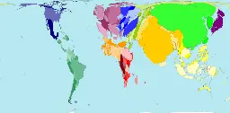
Biocultural Diversity: The interconnected manifestations of life.
> Our world is home to a magnificent variety of plants and animals and cultures and languages. But (in)human activity has increased the species extinction rate to 10,000 times the historically normal rate, and of the planet’s 7,000 languages, most are predicted to go silent in the next century. This is the biocultural extinction crisis – the converging losses of biodiversity and cultural diversity that will forever change our world unless we act now.
Source: The Decolonial Atlus: https://kolektiva.social/@decolonialatlas/108822356455332478
-
Disputed Areas and Breakaway Regions - Map Quiz Game
www.geoguessr.com World: Disputed Areas and Breakaway Regions - Map Quiz Game - SeterraIn this quiz, you can learn about countries with limited recognition, breakaway regions and disputed areas.
-
Members of UNPO (Unrepresented Nations and Peoples Organization)
The Unrepresented Nations and Peoples Organization (UNPO) is an international organization established to facilitate the voices of unrepresented and marginalised nations and peoples worldwide.
Source article: https://en.wikipedia.org/wiki/Unrepresented_Nations_and_Peoples_Organization
-
how an informational map can further anti-migrant sentiment
thecorrespondent.com How maps in the media make us more negative about migrantsWhether we’re looking at The Correspondent, the world atlas or the national news, migration across the Mediterranean is depicted on maps as thick red arrows heading towards us. Far more than we realise, these arrows define how we view migration. Can that be changed?
Illustrates the relevant Wondermark depressingly well. I despair at the idea that correcting incorrect facts is enough.
-
Five maps that will change how you see the world.
theconversation.com Five maps that will change how you see the worldNothing is where you think it is.
-
Geological Map of Iran - 1957 - CREDIT: @geo_spatialist on Twitter
This is a render of a normal paper map showing the geology of Iran created by @geo_spatialist on Twitter.
Iran has a dark history of CIA and MI6 involvement which lead to the coup d'état against him -- after he had implemented policies that threatened the profits of British Petroleum.
-
All the roads, trails, and highways of Canada
As you can see the vast majority of Canada's population lives very close to the U.S border.
The reason why Alberta and Saskatchewan have so many roads in a grid pattern is due to the farming and ranching that happens in these provinces, with perpendicular roads crossing through the different plots of land.
-
The difference between modern-day Lake Chad and the Holocene Lake Mega-Chad
Lake Chad is one of the many endangered bodies of water around the world.
As a result of water over-use due to agriculture, the size of the lake was rapidly shrinking, however, in the past 10 years, statellites have noticed a modest growth in the Lake's size. Let's hope that this new trend will continue, otherwise 10s of millions of people will be left without access to fresh water in an otherwise arid region.
If you'd like to read more about the lake, check out it's wikipedia article!
-
Elevation Map of Japan
Japan has a very interesting geography. On one hand you have massive mountains that are very steep, and suddenly you drop to these extremely-flat plains that are close to sea-level.
On the central part of Honshu island (the biggest Japanese island), there is the Kansai plain, the largest city here is Osaka. Towards the east, you can see the Kanto plain which is also home to a massive population, and the largest city in the world by metropolitan population -- Tokyo (pop. 37,274,000).
The vast majority of Japan's 100+ million people live in these relatively small and flat plains.
-
Tree Species Diversity in the United States
For anyone wondering, the small red spot in North-Western Florida is a nature refuge which contains some extremly rare species of plants.
-
Land use in England
As you can see, the Green Belt zones are the only things keeping England from becoming one big & continous urban sprawl of cities from South London all the way to Liverpool. :office building: :deciduous tree: :office building: